شما اینجا هستید

نشانی: 11734 WILSHIRE BLVD APT C1106, LOS ANGELES, CA 90025-6460, USA

؟90025-6460 چیست 90025-6460 یک کد فشرده 5 به همراه 4 عدد از 11734 WILSHIRE BLVD APT C1106, LOS ANGELES, CA, USA است. اطلاعات بیشتر در زیر آمده است.

90025-6460 اطلاعات اولیه

img_Postal
  • کد پستی 5 به علاوه 4:

    90025-6460
  • کد پستی 5:

    90025
  • به علاوه 4?
    4-digits that are used to identify a geographic segment within the 5-digit delivery area, such as a city block or a group of apartments or an individual high-volume receiver of mail, or any other unit that could use an extra identifier to aid in efficient mail sorting and delivery. This code is the low end of the range of +4 Codes that pertain to this ZIP Code. ZIP+4 Codes associated with nondelivery areas are composed of valid ZIP sector numbers and "ND" for the ZIP segment number, for example 12345-12ND. Non-deliverable areas are areas to which the USPS does not deliver mail, such as vacant lots and land that borders railroad tracks. Mailers should not match an address identified as a nondelivery area. If you absolutely must have numeric characters in the Plus4Code column, you may treat "ND" values as "00" (zero zero).
    :
    6460
  • کشور:

    U.S. - ایالات متحده
  • دولت:

    CA - کالیفرنیا
  • شهرستان:

    CountyFIPS: 06037 - Los Angeles County
  • شهر:

    LOS ANGELES
  • خیابان?
    The official name of a street as assigned by a local governing authority. The Street Name column contains only the street name and does not include directionals (EAST, WEST, etc.) or suffixes (ST, DR, BLVD, etc.). This element may also contain literals, such as PO BOX, GENERAL DELIVERY, USS, PSC, or UNIT. Numeric street names that have numeric components that are four characters (or less) in length at are justified such that the low-order digit of the number is positioned in the fourth position of the street name column. This shift is made so that the numeric street names appear in numeric sequence.
    :
    WILSHIRE BLVD
  • پسوند خیابان?
    The street suffix: For Example: ST = Street RD = Road DR = Drive LN = Lane
    :
    BLVD
  • نوع ثبت?
    An alphabetic value that identifies the type of data in the record. Record type codes include the following: G = General delivery H = Highrise F = Firm S = Street P = PO box R = Rural route/highway contract
    :
    H: Highrise

نشانی

img_region

90025-6460 مربوط به آدرس های زیر است.

لیست آدرسوضعیت
11734 WILSHIRE BLVD APT 1101 (From 1101 To 1106), LOS ANGELES, CA 90025-6460, USAمعتبر
11734 WILSHIRE BLVD APT C1010, LOS ANGELES, CA 90025-6460, USAمعتبر
11734 WILSHIRE BLVD APT C1104, LOS ANGELES, CA 90025-6460, USAمعتبر
11734 WILSHIRE BLVD APT C1101, LOS ANGELES, CA 90025-6460, USAمعتبر
11734 WILSHIRE BLVD APT C1102, LOS ANGELES, CA 90025-6460, USAمعتبر
11734 WILSHIRE BLVD APT 1007 (From 1007 To 1010), LOS ANGELES, CA 90025-6460, USAمعتبر
11734 WILSHIRE BLVD APT C1105, LOS ANGELES, CA 90025-6460, USAمعتبر
11734 WILSHIRE BLVD APT C1009, LOS ANGELES, CA 90025-6460, USAمعتبر
11734 WILSHIRE BLVD APT C1103, LOS ANGELES, CA 90025-6460, USAمعتبر
11734 WILSHIRE BLVD APT C1106, LOS ANGELES, CA 90025-6460, USAمعتبر

نشانی مثال

img_region
آدرس از سطرهای زیر تشکیل شده است:
11734 WILSHIRE BLVD
LOS ANGELES CA 90025-6460
UNITED STATES OF AMERICA
یا برای اطلاعات بیشتر می توانید نمونه زیر را در زیر ببینید.

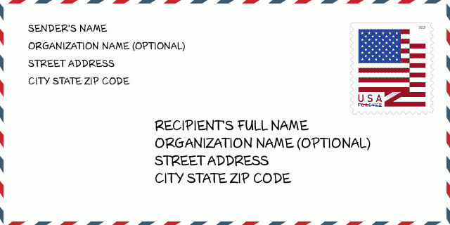
90025-6460 نمونه پاکت

img_envelope
  • این نمونه ای از پاکت نامه ایالات متحده است. اطلاعات فرستنده را در بالا سمت چپ و اطلاعات گیرنده را در پایین سمت راست وارد کنید. اطلاعات لازم نام کامل فرستنده/گیرنده ، آدرس خیابان ، شهر ، ایالت و کد پستی است. اطلاعات آدرس گیرنده برای مرجع شما داده شده است. به طور کلی ، اگر از کد پستی کامل 9 رقمی مطمئن نیستید ، فقط می توانید کد پستی 5 رقمی را پر کنید تا از دست دادن بسته جلوگیری شود.

    ZIP Code: 90025-6460

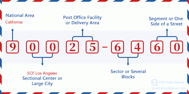
90025-6460 معنای اساسی

img_envelope
  • هر رقم کد پستی 90025-6460 مخفف چیست؟ کد ZIP+4 از دو بخش تشکیل شده است، پنج رقم اول را می توان در اداره پست قرار داد، و چهار رقم آخر می تواند یک بخش جغرافیایی را در منطقه تحویل پنج رقمی مشخص کند. 6-7 رقم بخش یا چند بلوک را مشخص می کند و رقم 8-9 نشان دهنده بخش یا یک طرف خیابان است.

    ZIP Code: 90025-6460

نقشه آنلاین

نقشه آنلاین

این نقشه آنلاین آدرس 11734 WILSHIRE BLVD, LOS ANGELES است. برای حرکت و زوم میتوانید از دکمه استفاده کنید. اطلاعات نقشه تنها برای مرجع است.

نشانی: 11734 WILSHIRE BLVD APT C1106, LOS ANGELES, CA 90025-6460, USA

دیدگاه

دیدگاه

افزودن دیدگاه جدید